
FORTE CULTURA Station: Defence lines La Línea de la Concepción (ES)
Defence bulwark against Gibraltar
Forts and bunkers from 300 years of fortification history
From 1730, Spain fortified itself on the northern border of the Gibraltar Peninsula, having previously tried in vain to recapture the Rock of Gibraltar, which England had taken possession of in 1704. At enormous expense, a defence line was built from coast to coast with 2 forts and 5 bastions and batteries - the Línea de Contravalación de Gibraltar.
The town of La Línea was not officially founded on this site until 1870, and the town charter was granted by King Alfonso XIII in 1913.
Between 1940 and 1944, the isthmus was once again fortified against the British Crown Colony of Gibraltar. This time with bunkered artillery positions, machine gun nests, watchtowers, mediation centres and command posts, some of which were built on the structures of the 18th century fortification line. These bunkers were part of a much larger defence line with a total of 478 structures that stretched along the coast from Conil de la Frontera on the Atlantic to the mouth of the Guardiaro River in the Mediterranean.
The extraordinary history of the region can be clearly traced today in the modern border and coastal town and is once again gaining great significance due to current events.
Learn about the lines of defence in La Línea know:


La Línea de la Concepción was an 18th-century line of defence against the Gibraltar peninsula. During the Second World War, a massive line of bunkers was added along the coastline between Cádiz and La Línea.
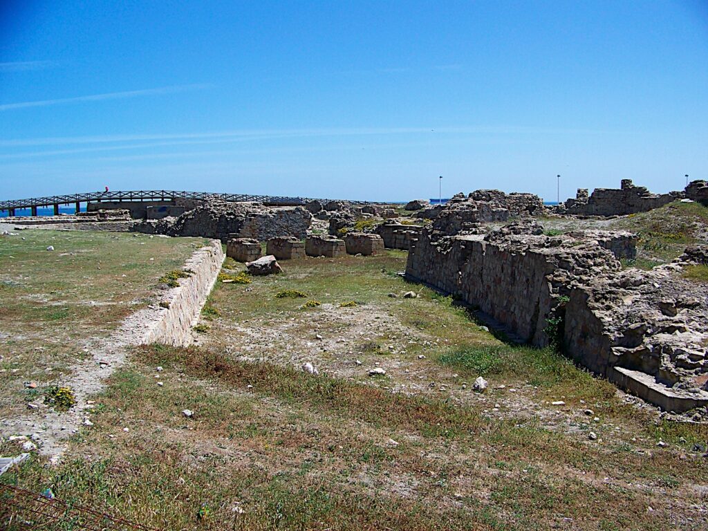
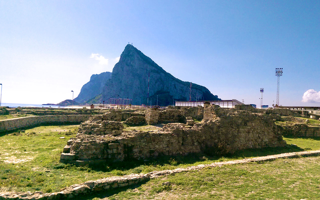
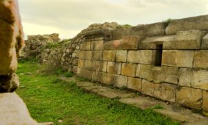
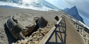
Ruins of the Santa Barbara fort
Fort Santa Barbara was the eastern fort of the defence line Línea de Contravalación de Gibraltar (Line of Defamation), which stretched across the isthmus in the 18th century. It was built by the Spanish in 1730. The destruction of the fort and the entire line took place in 1810 by Spanish-English agreement. Both sides feared that Napoleon could take over the fortified site and use the existing fortifications against both Spain and England.
The ruins were declared a Spanish national heritage site in 1994. From Levante beach, the extent of the former Santa Barbara fort can still be clearly seen today.
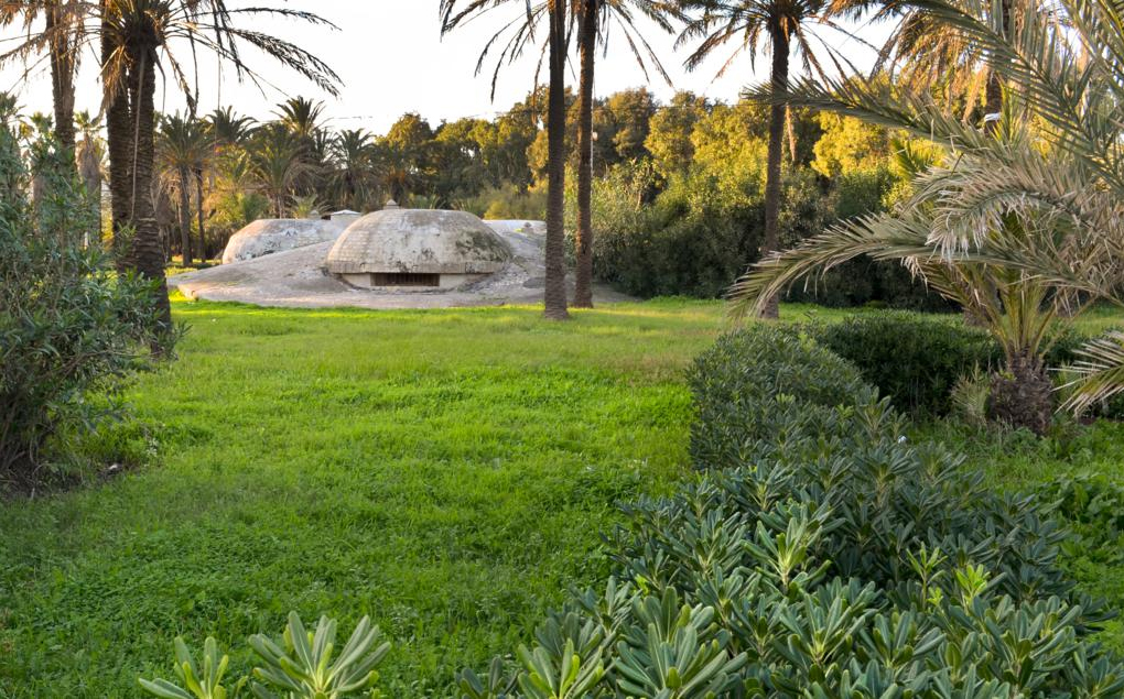
Reina Sofia„ Park“
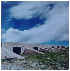
Embedded in the „Reina Sofia“ city park between Avenida del Ejército and Avenida Principe de Asturias is a large machine gun position consisting of 4 machine gun nests, each with 3 concrete domes. The south-eastern machine gun nest was also equipped with an anti-tank gun as flank protection. The bunkers can be visited on guided tours.
The park was known as Parque Princesa Sofía, named after Sofia of Greece. When she became queen, the park was renamed Reina in 1975. It has an area of approximately 17.86 hectares.
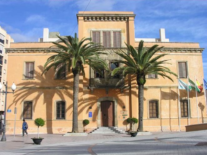
Isthmus Museum in the historic Kommandantenbau
The historic military commandant's office, the oldest building in the city (1863), is now home to the Isthmus Museum its headquarters. Various exhibitions provide information about the development from a garrison base to a town and its eventful history. The military architecture and its epochs visible in the city are also illustrated. Other rooms house the „Francisco Tornay” municipal archives and several municipal offices, and national and international art exhibitions are organised.
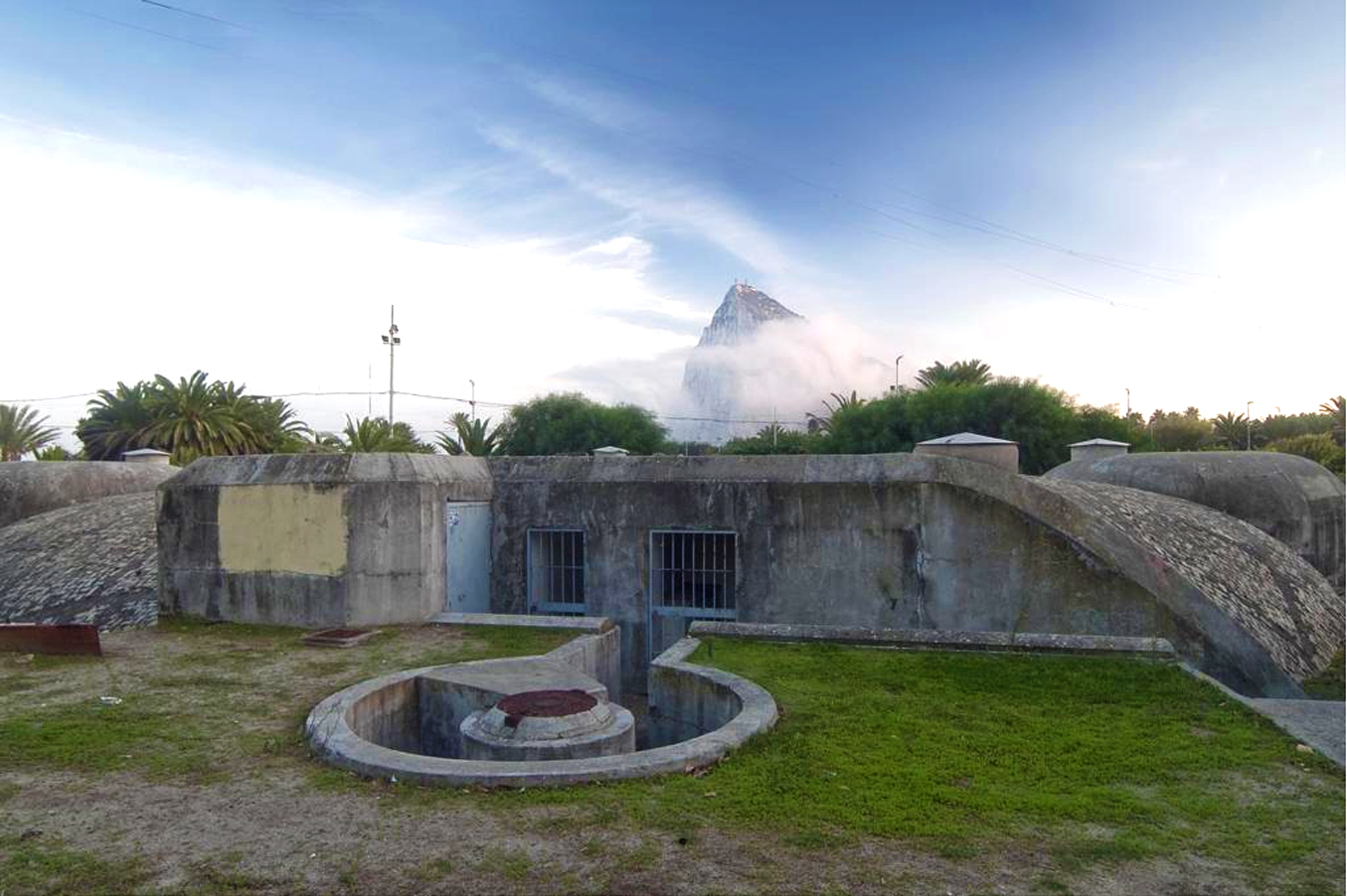
Bunker on the isthmus of La Línea
After the Spanish Civil War, the Franco regime built numerous defences along the Spanish Mediterranean and Atlantic coasts. Of particular note is the Campo de Gibraltar defence system, which stretches along 90 kilometres of coastline and comprises more than 500 bunkers, including in La Línea de la Concepción. The facilities were built with considerable material and human resources, often using forced labour.
Today, the bunkers are silent witnesses to an era. They blend harmoniously into the coastal landscape and offer visitors the opportunity to immerse themselves in history and understand the strategic importance of these structures. A visit to these historic sites is not only worthwhile for history buffs, but also for anyone who wants to experience the unique landscape and the impressive engineering skills of the time.
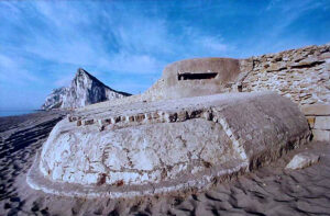
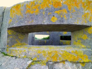
Camouflage bunker
Bunker 154 is a huge anti-tank post with six partially dismantled rooms on a plot of land on Avenida Príncipe de Asturias and Paseo Andrés Viñas. Thanks to its „civilian“ roof and simulated doors, it remained undiscovered for fifty years.
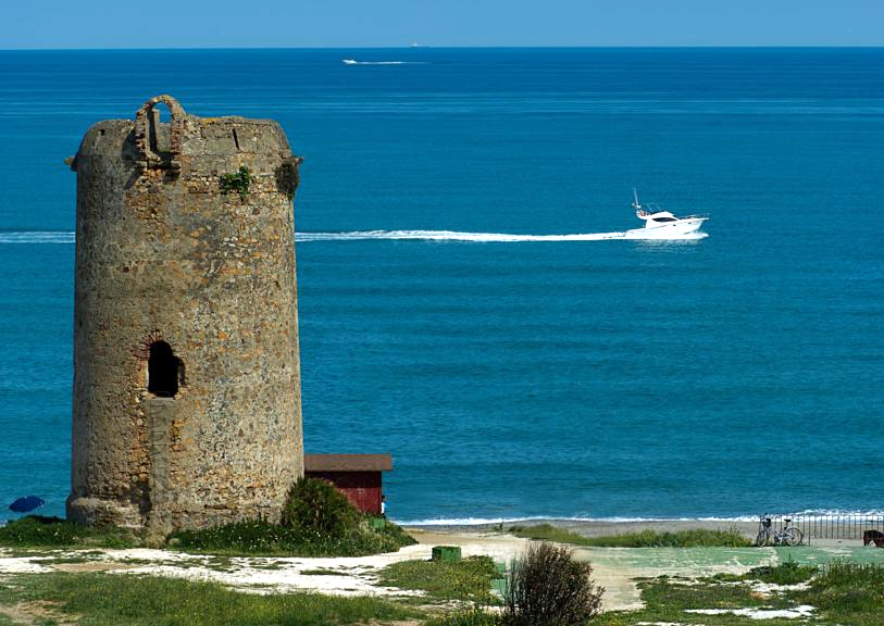
Torre Almenara
The Torre Almenara is located on the Playa de Torrenueva. It is one of 44 watchtowers between Guardiaro and the Portuguese border that were built during the reign of Felipe III at the beginning of the 17th century. They were intended to protect the Spanish coasts from Berber pirates and other threats. The towers stood within sight of each other. If necessary, fires were lit on the towers to alert the defence and warn the population with smoke and light signals.
The Torre Nueva measures 7.25 metres in diameter and 12 metres in height. It has been a national monument since 1949.
Tourist information in La Línea de la Concepción: city tours, bunker tours and events
The watchtowers (Torres Almenaras)
Coastal hiking trail from Manitiva to Maro (watchtowers),
North route without La Línea

History
The history of La Línea de la Concepción begins long before the actual founding of the town in 1870.
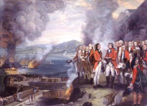
The trigger for all this was the occupation of Gibraltar by England during the War of the Spanish Succession England and the Netherlands joined forces at short notice and, under the leadership of the Prince of Hesse Darmstadt, conquered the heavily fortified but understaffed peninsula in a coup d'état.
In order to prevent a reconquest, the fortress of Gibraltar was expanded and sufficiently manned at short notice. The Spanish-French alliance then attempted to besiege and recapture the peninsula from land and sea with up to 14,000 men and several fleets. After unsuccessful attacks and heavy losses, the siege was finally transformed into a passive blockade in January 1705, the harbingers of the later Línea de Contravalación de Gibraltar.
In 1713, Gibraltar was officially granted to Great Britain in the „Peace of Utrecht“. Nevertheless, Spain attempted to recapture it in early 1727 during the Anglo-Spanish War, again without success.
From 1730 Spain had the Línea de Contravalación de Gibraltar in order to definitively seal off Gibraltar from the mainland and establish a base for further attempts at reconquest in the future.


Architecture
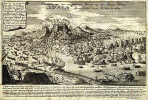
Línea de Contravalación de Gibraltar
On behalf of Spain Marquis of Verboom in November 1730 with the construction of the 1700 m long defence line. At a distance of 1800 metres from the Rock of Gibraltar, it stretched from the Mediterranean coast to the Bay of Algeciras, blocking the land route to the peninsula.
The line of fortifications was designed as a continuous redan line with five triangular bastions: San Carlos, San Fernando, San José, Santa Mariana and San Benito. At the ends, Fort Santa Barbara was built in the east and Fort San Felipe in the west. The line of fortifications was largely straight, although a bulge was created at Fort San Felipe to make room for an army.
The broad Fort San Felipe had 28 gun positions (20 iron 16-pounders, 4 iron 6-pounders and 4 13“ brass mortars) and provided a wide field of fire across the bay and into the city of Gibraltar. The fort also had several casemates, two bastions and a curtain wall at the rear, as well as a moat that could be flooded from the sea.
The Santa Barbára fort was built in a pentagonal shape and aligned like an arrowhead towards Gibraltar. It had 24 gun positions, a dry moat, a covered path, a glacis, 4 bombproof casemates and a sea wall against the surf. The fort was equipped with 12 iron 15-pounders and a 13“ brass mortar, the peacetime garrison consisted of 50 men plus a captain.
Sistema de Defensa del Campo de Gibraltar
Looking at the disposition, armament and tactical purpose, three perfectly differentiated zones can be distinguished: The Pre-defence zone was divided into two anti-tank barrier lines, consisting of a line of six rows of „dragon's teeth“ and a line of thick metal posts reinforced with barbed wire. The anti-tank defence lines ran roughly parallel and were only interrupted by the road to the colony. The pre-defence zone no longer exists today.
The second defence sector consisted mainly of machine gun nests with three cupolas each. Their mission was to defend against infantry attacks on the one hand and to protect the nearby artillery positions on the other. The defence zone was reinforced on its flanks and on both sides of the access road to Gibraltar by several anti-tank obstacles.
The third defence sector consisted mainly of armoured positions for field artillery, with some anti-tank positions in the centre. Its total equipment totalled 35 pieces, 27 of which were equipped with 66-mm infantry guns, the well-known 6’5 „Legionario“.
Two extraordinary bunkers derive their originality from their disguise as civilian buildings. Bunker 154 is a huge anti-tank post with six partially dismantled rooms on a plot of land on Avenida Príncipe de Asturias and Paseo Andrés Viñas. Thanks to its „civilian“ roof and simulated doors, it remained undetected for fifty years. A two-storey command post, also perfectly camouflaged, is located between the houses on Avenida de La Banqueta.
La Línea de la Concepción and its surroundings offer an impressive natural experience that combines both the coastal landscape and the rich history of the region. The picturesque coastline stretches over 90 kilometres. The region is characterised by a diverse flora and fauna that stretches along the coast and inland. The proximity to the sea and the varied landscape make La Línea and the surrounding area an ideal place for nature lovers and outdoor enthusiasts. Whether hiking, bird watching or simply a relaxing walk along the coast - there is something for everyone to discover here.
A particular highlight is the Campo de Gibraltar defence system, which, with over 500 bunkers, not only represents an important historical heritage but also offers a unique natural experience. The bunkers are now silent witnesses to a time when Spain was preparing for a possible invasion that never materialised. They offer a fascinating contrast to the natural beauty of the coastal landscape and invite you to explore the history and nature of the region in equal measure. A visit to La Línea de la Concepción and the surrounding area is therefore not only worthwhile for history buffs, but also for anyone who wants to experience the unique landscape and impressive engineering of the time.


Events in La Línea de la Concepción
Wenn du dies siehst, nachdem deine Seite vollständig geladen wurde, fehlen leafletJS-Dateien.
Schreibe einen Kommentar